TECHBYTES:-BROADBANDmap
BROADBANDmap
About
Map contents
This map shows where Internet service is available in the United States as reported to the FCC by Internet Service Providers (ISPs). Maps are continuously updated to improve accuracy through a combination of FCC validation work, new data from ISPs, location data updates, and importantly, information from the public.
How to use this site
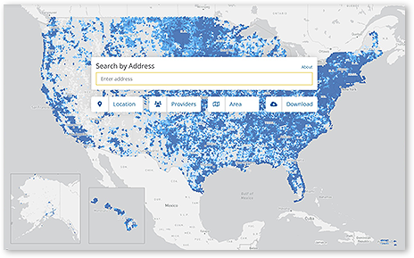
What can I do from the home page...
Enter an address in the Address Lookup window to zoom to that address point on the map. Entering the address will display information about the location, a list of ISPs that can service the location, and the type and speed of service offered.
Pan, zoom, and generally explore the map or click Places to find a location.
How You Can Help Improve Your Maps
As a map user, you can support the ongoing process of improving your data in one of the following ways.
If your residence location information or another location is incorrect, you can submit a location challenge from Maps. You can also submit a location challenge if your location is not on the map.
If you believe that the information on the map about an ISP that provides broadband service to your home or other location is incorrect, you can dispute this by challenging the availability from the map. can. If you think the coverage information for your,mobile phone is incorrect, you can also dispute this by running a speed test on your mobile using the FCC Speed Test App. The results of these tests are aggregated to create mobile challenges that mobile operators must address to improve their coverage maps.
The availability data displayed on the map is provided by ISPs through the FCC's Broadband Data Collection (BDC). As part of the BDC, all ISPs are required to submit data twice a year to the FCC regarding where they use their broadband network equipment to provide mass-market Internet access services.
ISPs that provide broadband internet in fixed locations (such as homes and small businesses) should report by location the locations they serve (the same locations shown on the map) .
Mobile operators use propagation modeling to generate 3G, 4G LTE and 5G NR coverage areas displayed on maps. The model incorporates certain common settings for consistency. A coverage area is intended to represent an area where a user can establish a mobile connection outdoors or in a vehicle and achieve specified upload and download speeds. Please note that the map does not include information about indoor mobile wireless broadband service availability. Coverage maps are based on propagation modeling, so the actual onsite experience may vary depending on factors such as end-user devices used to connect to the network, cell site capacity, terrain, and other factors. The wireless service provider's coverage map on his website may be based on other parameters and assumptions such as: B. Availability of services provided by roaming agreements. Therefore, it may differ from the information shown here.


Comments
Post a Comment